MIAMI (AP) — Hurricane Priscilla weakened in the Pacific as it moved Wednesday along the west coast of Mexico while Tropical Storm Jerry in the Atlantic was expected to strengthen on a track for the Leeward Islands, forecasters said.
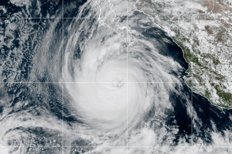
Priscilla on Tuesday approached major hurricane status, but by Wednesday morning was a Category 1 storm with maximum sustained winds around 80 mph (129 kph), the U.S. National Hurricane Center in Miami stated. Despite the downgrade, heavy rainfall and the risk of flash flooding were still forecast for the week along Mexico's Pacific coast and later into the Southwestern United States.
The storm was moving northwest at 8 mph (13 kph) and was located about 195 miles (314 kilometers) southwest of the southern tip of Baja California. Meanwhile, in the Atlantic, Tropical Storm Jerry was maintaining top winds of 50 mph (80 kph) and was positioned about 835 miles (1,344 kilometers) east-southeast of the northern Leeward Islands, moving west-northwest at 23 mph (37 kph).
Forecasters estimate Jerry will strengthen into a hurricane Thursday, with the storm's center expected to be near or north of the northern Leeward Islands late Thursday and Friday.
On Thursday into early Friday, 2 to 4 inches (5 to 10 centimeters) of rain may fall across the Leeward Islands, raising the risk of flash flooding. A tropical storm watch has been issued for regions including Antigua, Barbuda, Anguilla, as well as St. Kitts and Nevis.
In the Pacific, a tropical storm watch due to Hurricane Priscilla was in effect for Baja California Sur, stretching from Cabo San Lucas to Cabo San Lazaro. Priscilla was on track to weaken further Wednesday, with major hurricanes classified as Category 3 or higher, boasting wind speeds of at least 111 mph (180 kph).
Additionally, large waves generated by Priscilla affected regions along the southwestern and west-central Mexico coasts and parts of the southern Baja California peninsula. Further out in the Pacific, Tropical Storm Octave was depleting about 720 miles (1,159 kilometers) southwest of Baja California's southern tip, with maximum sustained winds of 40 mph (64 kph). This storm was anticipated to dissipate by Thursday night and posed no threat to land.