In brief
A sudden flood surged through the Gyirong‑Rasuwagadhi crossing at 08:37, triggered by a glacier collapse and lifted into a wall of water, mud and rock that buried buildings and vehicles. Video footage from the site shows the torrent at 10:59:53, while a satellite image illustrates the area just before the disaster. Immigration records reveal 89 passengers had cleared exit controls in the minutes before the wall of water appeared, yet 275 Indians remain missing in Nepal. The flood not only devastated a vital trade route but also highlighted the vulnerability of the region’s infrastructure.
At 10:59:53, CCTV footage captured a dark wall of water, mud and rock rushing through Gyirong, the Chinese side of the Nepal‑China border. The instant glimpses of the torrent revealed its sheer size and speed before it crashed through the border, Mading the scene for the world.
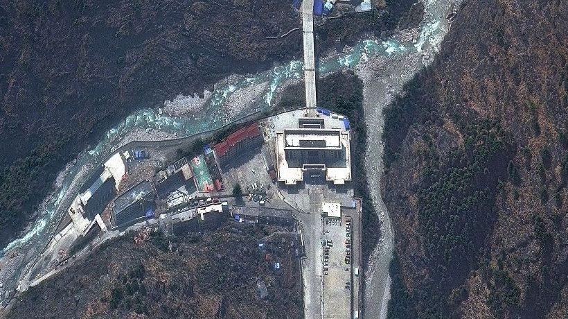
Satellite imagery taken days earlier shows the border complex and the narrow gorges that feed the river network. The image reveals how the valley floor was lined with houses, hotels, shops and a hydropower substation—everything that was later swept away by the flood.
Immigration logs at the Rasuwagadhi checkpoint indicate the last exit transaction at 08:35:03 local time. Four officials, including the head of the post, disappeared when the water surged. Aerial footage shows the spill reaching the bridge seven minutes after the glacier collapse triggered the torrent.
Senior immigration assistant Tika Ram Pokharel, who was in Kathmandu for an exam, was the only staff survivor. He relays that roughly 300 to 400 people were waiting to cross when the flood struck, with 32 Indians, 12 Chinese and 9 Americans part of the final recorded departures.
At least 275 Indians remain missing in Nepal, according to India’s foreign ministry, while Nepali accounts at Rasuwagadhi show 53,742 crossings in the year to mid‑July.
Hydrologists point to the glacier collapse as the main trigger, noting seismic vibrations registered at 08:37, barely two minutes after the last recorded immigration transaction.
The disaster has halted a crucial artery that handles about 80% of Nepal’s electric‑vehicle imports from China and passes 60 to 70 trucks daily. Trade disruptions have forced Nepal to depend on the now‑closed Tatopani. The governorate urges an alternative route and safer design for future hydropower projects along the river.
Rescue teams reached Gyirong on 28 August, reporting that “there was nothing but ruins.” The crossing has just recovered from a July 2025 flood that held Rasuwagadhi closed for six months.